Sunday, August 31, 2008

Aug 15-18 – Heading to Pep, NM


As we left Cody, I received a call from one of my sisters informing me that my brother, Richard, had been admitted to the hospital in Fort Worth, TX. They thought it might be cancer and would be performing surgery on him the following Monday. Not a great way to start this leg of our journey.

We followed SR 14 west out of Cody and entered Yellowstone National Park through the East Entrance. Again, a beautiful drive, Bryan and I thought it was more scenic than the West Entrance. We didn’t linger in Yellowstone – stopped and had lunch near the Visitor Center and then again to walk the West Thumb Geyser Basin.


Then on through Grand Teton National Park - beautiful. We will come back one day and do a bit more exploring.

We made it into Jackson, WY around 6 PM and called it a night. We stayed at a very, very expensive and not the greatest KOA just south of Jackson. $61 a night for water & electric and it was PACKED. Beggars can’t be choosers I guess. Tomorrow Grand Junction, CO.

We left Jackson, WY on the 16th to head to Grand Junction and then on to Ourey/Silverton, CO where we planned to spend a few days touring old mines and forest service/Jeep roads. My sister called again, this time to inform me that Mom was worried about Dad’s incision area. So I called Mom and she said she was headed to the emergency room with Dad in tow. His incision area was quite bruised and had some swelling. We opted to forego the rest of our trip and just head straight on down. From Grand Junction we hit I-70 and headed to Colorado Springs. Our first time on I-70, it was a beautiful drive too. Steeper than we expected on an interstate but a nice drive. We hit snow around the Aspen/Breckenridge area and then rain into Denver – making for a horrible Sunday evening commute!! From Denver we headed to Colo Springs and the Golden Eagle Ranch RV Park.

What a nice BIG park this was, although it could definitely be dusty during a dry spell, we happened to hit it on a rainy day and it was quite muddy in some spots. The park is fairly large – having a group site with 500 spaces and a 5000 sf meeting hall. There are 200 regular sites, many with full hook-ups. The bathrooms were clean, albeit a bit older and had nice showers. As we headed out of the park to find dinner we saw a huge bobcat. It was out in group site area and paused for a photo op before trotting across the road in front of us. Then paused in the bushes for another photo op.


We pulled into Pep, NM around 4 PM on Monday, August 18th. Dad was doing well, we took him into Lubbock, TX for a check up and his doctor said his swelling and bruising was normal and could get worse before it got better. Arteries all looked good (he performed a CAT scan at this appt). So, yea! Dad’s doing well.
The next few installments will be life at the ‘ranch’… I hope all of you are doing well and life is treating you kind. Thank you for your prayers and good thoughts for Dad and now I ask you add my brother to your prayer lists. He has colon cancer, but seems to be doing well and planning on starting chemo & radiation treatments soon.

Aug 14-15 – Cody, WY


What a neat town this is. Very touristy of course but very fun. I want to go back there and explore a bit more. We were able to see most of the Buffalo Bill Historical Center – housing five museums. We saw the Winchester Gun Museum, The Plains Indian Museum, The Western Art Museum and the Bill Cody Museum, the one we missed was the Draper Museum of Natural History – maybe next time.
There is so much to see in do in and around Cody. There is the Buffalo Bill Dam Visitor Center, a nightly rodeo, gunfights, the Old West Miniature Village, and Old Trail Town that has buildings from around the west including buildings from “Hole in the Wall” – a favorite hideout of such outlaws as Butch Cassidy and the Sundance Kid. And so much more. Unfortunately, we weren’t able to see any of it – so I guess we’ll have to go back.

Aug 14– Beartooth Pass


What a drive! It was so incredibly beautiful! We started out from Cody, WY on SR 120 then met up with SR 212 which encompasses the Beartooth Pass. After driving the “loop” we both decided that the WY side was much more scenic than the MT side, but all in all it was a beautiful drive. Unfortunately the day of our drive it was overcast and cold! Really cold! There were several bikers (motorcycles, not bicycles) up there and all we could think was “MMMM, that looks like fun! NOT!!’ It was so cold, I can’t even imagine how they made it. Most were bundled up and had scarves over their faces but many weren’t. Brrrrr!
The loop took us about 5 hours to drive. We made several photo stops and once for gas at “The Top of the World”, a small store, gas station and campground just a few miles from the pass. Surrounded by mountains, small mountain lakes, huge boulders... it was a beautiful setting. Hopefully some of the pics will do it justice. If you ever get a chance to go – DO IT! Just don’t take an RV on the road – it is really narrow, very winding and two way traffic. There were a few RVs on the road but I wouldn’t recommend it.

Aug 13 – On the Way to Cody, WY

Sorry its been so long... family stuff... and sporadic high-speed connections. Not fun working on a 28.8 dial-up! I'll continue the trip and then do some catch up on the personal side.

We headed south out of Garryowen on I-90 and then took SR 14 west toward Greybull, WY. What a scenic road. Lots and lots of switchbacks and steep grades but beautiful vistas always awaited around the next bend. About halfway through I convinced Bryan it would be great to swing by the Medicine Wheel National Historic Landmark which is located off of Alternate 14 (SR 14A). We took the detour and again found ourselves on a pretty steep and winding road. The turn off for Medicine Wheel was a bit of a surprise – a one and a half lane dirt road winding up a steep mountainside – of course we were in the truck/camper towing the Jeep so that always makes is ‘easy’. We made it up, just to find out that from the parking lot for MWNHL you had to walk another 1.5 miles. Any other time we would have done it but we wanted to get to Cody at a decent hour and we had Bear with us – it was too hot to leave him in the truck for any length of time so we’ll just have to come back. I would love to visit this ancient spiritual place. It is believed that the Medicine Wheel was constructed between 1200 & 1700 AD. It is approximately 245 feet in circumference with a central cairn and 28 spokes that radiate out from the center to the outer rim. The Medicine Wheel is quite an enigma – no one really knows why it was built or how it was used and legends and stories abound on its uses.

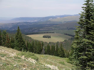
View from Medicine Wheel's Parking lot


The road down from MWNHL had a 10% grade and several switchbacks, dropping 3600 ft in 10 miles! To say Bryan was nervous would be an understatement. Bear didn’t like it either – not sure if it was the altitude or the switchbacks or the combination but he was a nervous wreck too. He was about to crawl from the back into my lap down to the floorboard by the time we got down.

Due to the detour to MWNHL we bypassed Greybull, and headed over to Lovell. We crossed the southern end of Bighorn Canyon National Recreation Area. Once we got down out of the mountains the land leveled off with more mountains in front of us. We followed SR 14A through Lovell and then to Powell, WY where we took several photos of water towers and city signs. LOL
We made it to Cody and found space at the Ponderosa RV Park located pretty much in downtown Cody. This was an OK park, very clean but VERY crowded! After this trip we are certainly not enamored with private parks; preferring the relative quiet of the state & national forest campgrounds… However, this park was very convenient as a base to explore Cody and to start our Beartooth Pass loop.


Friday, August 15, 2008

Aug 15 - Dad Update

Dad had to have a stint put in on Wednesday as they found 99% blockage in one artery. He was able to go home on Thursday (8/14) and was at a weiner roast tonight. For those that know my Dad, he is the consummate workaholic. Always doing something - he is supposed to not do ANYTHING for 2 weeks. It won't be his heart that gets him - it will be boredom or Mom nagging him to death.

Anyway, we are all celebrating this bit of good news - they caught the blockage in time thanks to Mom "tattling on him to the Doctor" (Dad's words). I'm just glad she did. Thank God!!

Hope all of you are doing well and if I can get still & with a reliable internet connection I'll post the last few legs of our journey. We have seen some BEAUTIFUL country! Special thanks to Jim V for his Beartooth Pass suggestion! Awesome!

Tuesday, August 12, 2008

Aug 12 – Custer’s Last Stand

Today we left Three Forks around 10 AM. I had called and talked to Dad & Mom. Dad “should have been putting a toilet in the new Pep Community Center, not laying in bed with nothing wrong with him”. Mom seemed better too – the doctor had come in and said things looked OK, he would do an angiogram/plasty – I can never remember which – Wed morning and perhaps put in a stint or two. Maybe… if no stints, then Dad would go home on Wed. If he got stints then he’d go home on Thursday. There is a very, very slight chance of heart surgery but they wouldn’t know that until after the angio-whatever. That should take place Wed morning around 7 AM.

Again Dad insisted we not change plans & I not try to fly down there. So, we headed to Billings, MT then on to the Little Bighorn Battlefield. We camped in a nice little campground just out of Garryowen, MT – The 7th Ranch RV Camp. It is spread up a hill facing west (fantastic sunset!!), with 41 pull thru sites with water/electric and some with sewer and about 20 tent sites. There are also 4 small cabins for rent. The views cannot be beat – of course we don’t have anyone sitting in front of us so that helps.
7th Ranch RV Camp

The Battlefield is open until 7:30 but the driving tour loop is closed at 7 PM. My advice is to get the driving tour CD – it outlines what you are looking at in much greater detail than the plaques along the way (7th Ranch RV will loan one to you free of charge). I also wouldn’t go up the loop in an RV but people did. It is really a desolate place, serene and beautiful. I can’t imagine the battle that ensued on those lonely hills and ravines. The stark white markers show where the soldiers had fallen but all bodies have been moved to either the National Cemetery there or to a mass grave located on “Custer’s Hill”. There are few red markers marking the fallen Native American scouts, mostly Crow, that were helping the US Army forces. The Native Americans picked up their dead & wounded and disposed of their remains as their traditions dictated. Most US soldiers were originally buried in shallow graves where they had fallen within three days of their deaths. A very tragic piece of history, not only for the US Calvary but to the Native Americans. While this proved a great victory for them, it didn’t help them much in the end of this black part of American history.

National Cemetery at Little Bighorn Battlefield


Trail past markers of fallen US Calvery men at the Battle of Little Bighorn
Markers show the soliders that fell on "Custer's Hill".

Tomorrow we head to Cody, WY if news of Dad is good. From there we’ll explore the Beartooth Mountains and take a trip over Beartooth Pass.

Aug 11 – On the road again & Dad scare

Finally – we got a call from Terry Truck Center at 10 AM saying the truck was ready to roll!! We “quickly” gathered our things and checked out of the motel. By the time we reloaded the camper (transferring stuff out of the camper to the Jeep, re-packing the clothes we had at motel, etc. We were heading east on I-90 around Noon.


At 12:08 PM I received a call from (Raymona’s) Mom. Dad had been having “chest pains” all weekend and while at the doctor for her check-up she mentioned it, much to Dad’s dismay. They immediately put in for a chest x-ray and EKG (I think that’s it) and said his heart wasn’t beating quite right. No heart attack but the doctor’s opted to send him on the Lubbock, TX for more tests. Lubbock has one of the best heart hospitals in the area and it about 2 hours away. They bundle him up in an ambulance and left Mom waiting for a neighbor to come get her from the hospital in Clovis, NM.

Nothing happened enroute to Lubbock, despite Dad trying to bribe (he’d buy their lunch) the ambulance attendants into stopping for lunch at Le’al’s in Muleshoe. Mom made into Lubbock a few hours later thanks to good friends, LaVerne & George. (A special thanks to them from me for taking care of Mom!)

Flash back to our trip – decision: do I try to fly out of Missoula and head down or wait & see what happens? Dad didn’t want Mom to even call us so that we would not interrupt our trip. Well, we decided to wait until we got to Billings, MT – If things looked dire (surgery) then I’d hop a plane down-otherwise we’d just straight down and get there when we could.
Cell service in Montana is sporadic at best. I did manage to get a couple calls in from sisters and another from Mom – all seemed to be well. Dad was safely ensconced in the University Medical Center in Lubbock with “stable vitals and no chest pains”, Mom had made it to the hospital, Shirley (sister) was going to head up. We made to Three Forks, MT by 8:30 PM and decided to call it a night.

A word about the wonderful little park we found. It was listed on our GPS software (Microsoft Street & Trips) as Three Forks KOA and also listed in the 2007 Trailer Life directory as a KOA but it wasn’t marked as a KOA. Anyhooo the “Camp Three Forks” is a delightful campground, just off of I-90 and SR 287. I think that would be the only negative I saw was the proximity to 287. If full, the sites could be close together I suppose but we had plenty of room with electric & water hook-ups. Cost was $28 per night. There was a small (very small) store, a big screen TV tuned to the Olympics, very clean restrooms and a pool. All of the sites that we saw were packed gravel pull thrus with small grassy areas with picnic tables. Lots of trees – everything was well shaded.

Another place of note in Three Forks is the Wheat Montana Bakery. Lots of pastries, bagels, etc for breakfast. I had a ham, cheese & egg bagel and Bryan had a breakfast burrito. So many types of breads to choose from… we chose Big Sky Wheat – we’ll let you know how it is.

Sunday, August 10, 2008

Aug 10 - Pend Oreille River and Wheat

We are still planning on picking up the truck & camper tomorrow early afternoon (hoping is more like it) and hitting the road. If all goes as planned we hope to make St Regis, MT by tomorrow evening on our way to Glacier National Park.
In the meantime, we took a quick trip up Hwy 2 to the Pend Oreille River (pronounced pond-er-ay) near Newport, WA. Unfortunately, we headed over Hwy 20 thinking it followed the river closely - look at a map, it does look like you'd be able to see it but... you really couldn't see much of the river. We should have kept straight on Hwy 2 and crossed it just north of Newport, I guess.

We did get some rain on the trip - just some heavy sprinkles but has kept the day cool.


Ranch near the Pend Oreille River


Looking back at Baker Lake along SR 211


Davis Lake along SR 211

Wheat - Wheat is the king of crops here in Eastern Washington. We've certainly seen lots of "amber waves of grain". It's actually quite beautiful to see the rolling hills covered in golden wheat. Washington is #6 in US wheat production - growing five classes of wheat: common, club, & Pacific NW soft white, hard white and hard red. Soft white is most commonly used in pastries, pancakes, cookies, cakes, & cereals while the hard white is used for asian noodles, yeast breads, hard rolls & tortillas and hard red is used for breads and all-purpose flour. There's lots of information on actual wheat production, exporting & importing wheat, etc on the web. What I couldn't find a lot on was how to grow wheat - when to plant the spring wheat vs winter wheat etc. Lots of scientific jargon but nothing I could distill down and make sense of.


Below are some photos of the wheat fields just north of Spokane along Argonne/Bruce Rd.


Here's Bear's favorite position after a hard day of riding around and sightseeing.


Saturday, August 9, 2008

Aug 9 - Coeur d'Alene Loop

Today we ventured out and did a beautiful loop around Lake Coeur D'Alene (pronounced CORE-DA-LANE). We headed south on SR-27 to Rockford then on to Plummer on SR-278. All beautiful rolling hills, some wheat fields that eventually break into lightly forested hills. Just past Plummer we started driving along the southern most edge of Lake Coeur d'Alene through the Heyburn State Park. Very scenic, when we could catch glimpses of the lake through the trees. We made a quick stop at Rocky Point then were back on the road.

Rocky Point, Heyburn State Park

After exiting Heyburn State Park we wound our way through St Maries (pronounced St Marys), the county seat of Benewah County. St Maries sits at the junction of two rivers, the St Maries and the St Joseph. Due to the abundant marshlands, and the cool nights & warm days of Northern Idaho, St Maries produces hundreds of thousands pounds of wild rice. The rice is harvested with an airboat, see the photo below (from www.wildriceonline.com/).


From there we headed north on SR-3 through the tiny little town of Harrison and on to Coeur d'Alene. About the only wildlife we saw were a family of wild turkeys crossing the road - two adults and three babies, very cute!

The Coeur d'Alene area is very beautiful with peek-a-boo views of the lake. The area has a lot of history and has several historical and heritage markers along the route we covered.